Title originally written in 2015. Lightly edited in 2025.
This essay was my first attempt at naming something I felt but couldn’t yet fully articulate—that cities, in the name of modernity, were quietly being engineered to divide.
Today, I think differently. But I still believe this idea was an early signal.
The follow-up essay, Division Urbanism 2.0, is now live here → [link]
The System Beneath the Street
The urge to be modern and the push of globalization that is observed in the metropolis and its consequences pressurizes the city of Addis Ababa to resemble the East, if not the West. The adopted structures present themselves as an alternative solution juxtapositioning next to the existing structures and lifestyle of the society, and shaping a new economic and cultural paradigm. The exposure extends from the intended function, which is the transportation system, to unintended consequences. The latter is the main inspiration for this paper.
The Illusion of Flow
The new issue that has been observed recently is the notion of the road that is diverted from its originated objective and use and became otherwise. The Addis Ababa newly proposed and under-construction roads created a new scenario other than becoming a connection of nodes. At the same time, roads seem to be blown out of proportion when compared to the surrounding fabric. The very of culture, social life and economic life seems to be discarded in both the LRT and the ring road. The society’s informal living that negates the formal modern Western construction has not been carefully considered.
When Separation Becomes Strategy
The new roads became an element of the division of neighborhoods. In Kelvin Lynch’s terms, it has become an edge rather than a path. An edge could often become a path. The difference of path from the edge, he says, is their character of one being a connection and the other being the end of a connection. An edge is rather a boundary or a feeling of boundary. It is the end of one and the beginning of the other. A similar issue is created with the new infrastructure of the city.
The major intention of the systems to connect the different districts of Addis Ababa by tram and car coincidently created an edge at the local level. This has been attained with the physical structure that separates two different settlements that used to be one and the strong mental image that the structures created in the observer’s mind.
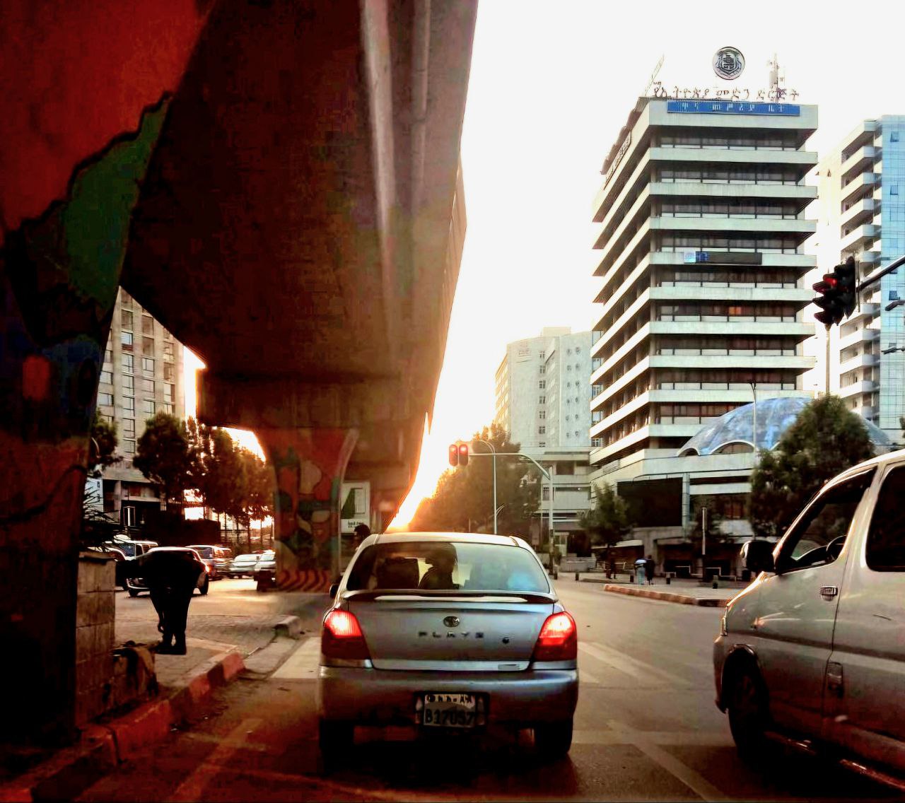
For lynch, what dominates, from path and edge, becomes it. Then both the LRT and the ring road of Addis Ababa are rather edges for the observer than a path for two main reasons. First, an observer cannot cross the roads or the railway, they move adjacent to it with the pedestrian bridge. Even elevated railways and roads are overhead edges, although their effect is eminent at the ground level. Second, they are paths with fast traffic, and their image or dominance could be altered by the stillness of the huge concrete and stone walls and iron fences around them.
The concept of division urbanism would challenge the very structure of the society.

Edging the path: mule path to complex armature
Historically, Addis Ababa was not more than a mere extension of the nearby cities that was founded with rural-type settlements. The majority of the paths were unplanned outcomes of forms and mule paths. The paths are often connections between the different huts that are located apart, surrounded by agricultural land or large open fields. These types of roads are also evident today near the city.
These usually diverge into villages in between farmlands. These paths are signatures of the movement of the residents. Their size could be proportionate to the frequency they are used since they are a simple production of dried meadow lines. These extend into other larger paths that go into farmlands, huts, sitting spaces, and cooking or laundry spaces.
A few decades after the founding of Addis Ababa, the need for better roads was evident. Roads then became the ultimate instance of being modern. Harold, in his book, A History of Ethiopia, mentioned Emperor Menilek, the founder of Addis Ababa, as the one who introduced the ‘modern age’ to Addis Ababa. He introduced paved streets. Inspired by the West, he saw the need for foreign skills in the construction industry and imported technicians from abroad who worked under his command. (Pankhurst, 1961)
The hired Western workers had the task of road building, planning, and implementation. Even after the war with Colonial Italy, road construction continued to be a sign of modernity, power, and imperialism. Armature was politics. The first railway, that is Addis Ababa- Djibouti railway, contracted by a French company, connected cities at the beginning of the 20th c. It served as a tool encouraging a linkage between the country and the rest of the world.
King Haile Selassie was also obsessed with road building as part of his progress programs with a thought to connect centres and encourage economic flow. (Harold, 1994) This was also achieved through creating large boulevards with shops and adjacent buildings to attract pedestrians.
At the same time, the level of advancement in the city was not as impressive for the colonial power of the time. Mia Fuller called the city ‘a small-scale town with unpaved roads’. (Fuller, 1996) The search for the modern, which was prototyping the West, the colonial power, was as strong in the city. Despite the effort, in the eyes of the colonialists, the city spaces were considered ‘undisciplined’, and the country had no ‘urban tradition’ for the colonial architects. (Fuller, 1996)
Out of the dominance of the colonial power of the 1940s came architectural and planning ideologies that shaped even today’s city. The ideology of segregation was reflected through the visibility of the segregated districts where the oppressor and the oppressed lived, separated but adjacent. Mobility was important in the separation- the oppressor accessed the whole city, and the oppressed stayed in the margin.
The 1936 Le Corbusier’s Addis Ababa plan sketch for the plan also had two quarters, the European and the Native quarter (Yitbarek,2008). Following the plan, the colonial power planned the city. The European quarter had an organic pattern, and the margin was a grid and formal. Roads were used as a tool for dominance and power; these limited movement and introduced formal patterns as a symbol of modernism and superiority. (Fuller M.)
Post the short colonial period, road construction in the country and the city continued to be a base for progress and a modern state. roads became an economic tool, a fast transportation of goods between regional centers. (Harold, 1994) Plans became radial, signifying decentralization. Abercrombie’s master plan of the 1950s, together with other elements, is an example of the aspiration to decentralize vehicle roads using ring roads. (Tesfaye, 2011)
After the 70s, the slight changes in the informal pattern of the roads in the city made them permanent structures in the spontaneous slum. Street upgrading in the slums by replacing materials, adjusting width, and adding services, negotiated the permanence and renewal of the streets. Upgrading a path becomes a criterion for the quality of an area. Construction material, geometry, or services provided with it all determined the quality of an area.
Roads became administrative boundaries/edges in the capital city, creating distinct administrative areas and communities. This made a mental image of two different neighbourhoods, although they share and live together as a settlement. Roads are edges for administrative zones even today.
Recently, Upgrading is no longer a viable solution. Renewal became an alternative solution for the city slums, accounting for 80 percent of the whole city. Roads evolved to become structuring elements.
The Addis Ababa Ring Road and the Light Rail System (LRT) are at the center of the separation. The notion of edging with roads is no longer imaginary but physical. First, the widening of roads to match the structure plan proposals demolished the adjacent houses, encouraging separation. The concrete walls and fast traffic limited pedestrian crossing, discouraging community relations.
The railways were at the center of street lanes, creating a physical and mental border with on-ground and flyover structures. The big columns and giant structures create a sense of separation between districts.
The single-purposed mule path turns out to be an alien structure of chaos and inclusion with the purpose of aesthetics, power through grandiose structures, and an ultimate immaterial solution to modernity.
Imported Planning, Local Consequences
Modern in Ethiopia could have different meanings and images. First, modernity for Ethiopians has always been Western. Since imperialism, Ethiopian emperors have been deeply hypnotized by the dissimilar reality of the West. Their ultimate goal was to modernize the country based on this fact. The education system, the building technology, and social life itself have been influenced by Western ideology.
‘’Its vastness, both in scale and size, inspired the locals. The road was seen as the first Ethiopian road… light rail system, first of its kind in the country. ‘’ Chinese media report
Second, Alien is modern. Recently, the third world has reinvented its ambitions and needs and is attracted to the east. China’s history and cooperation policy attracted the Ethiopian government. Big roads and buildings became famous in the city. Out of context looking proposals are growing in the city, disproving that modern is not only the West but foreign.

Reversal of the Road– What Division Urbanism Does
Modal share Walking transportation in Addis Ababa takes a 60.5 percent share of all trips that combines the bus and the taxi systems.
The new LRT and the ring road ultimately focused on geometry and traffic problems rather than the social or urban design issues. Their modern solutions were presented as ultimate, and the planners were the gods. This solution focused on the minority vehicles rather than the majority of public transport and pedestrians.
The objective is to “become modern.” Interestingly, being modern in the city has an equivalent meaning to becoming car-dependent. Almost all the new roads are designed for cars, and forget the pedestrians.
The pedestrian sidewalks are left unconstructed. In a 2005 study, almost 63 percent of roads in Addis Ababa did not have proper sidewalks. One could mention the controversy on the solution for its obliviousness to the existing figures since the proposals discourage walking by their twisted and vehicular traffic-oriented designs and undersigned pedestrian walkways.
Residents avoid the ring roads except they illegally jump over the concrete walls to cross. This includes children going to school and mothers crossing to reach their previous marketplaces. Every day, they cross the road with four lanes, up to 40 meters wide, and 80km/hr traffic. The road circles around the city, separating neighborhoods. Crossing the ring road, east to west and north to the light weight rail adds to the problem
Together, this limited interaction separated the neighborhoods. This, however, also limited the social interaction and the search for uses across the street. The social system that existed for ages is interrupted by structures.
Conclusion: Cities That Divide Cannot Hold
Division is the new trend of urbanization model in Addis Ababa. The notion of the path that began as a simple alley and a line segment became something else, rather unintended. Roads in the city once were a physical boundary between administrative units, but their effect was only mental. However, the recent roads are physical barriers rather than paths.
First, the separated urban settlements grew to have completely different plans and building structures, creating a different settlement.
Second, shared uses that are noticed in the low-income neighbourhoods are separated across the streets by bridges. The adaptation to a new function in the same location or crossing the margin informally to find the existing function created a new social lifestyle.
Third, these infrastructures created a visible physical edge where crossing is minimized. The notion of path as edge, seen in the past, that is, usually imagery, is now physical.
This image of the city is not intentionally created but are the antithesis of the road that had planned to separate car and pedestrian, but ended up dividing the urban fabric. The very idea of a path as a walkway is now a concrete fence separating entangled poor neighborhoods where lives depend.
As Anthony Downs quoted, solutions sometimes become a challenge or a source of challenge or irrelevant to the problem. On the other hand, the solution creates a new scenario that becomes a new reality: the division of Urbanism.
More
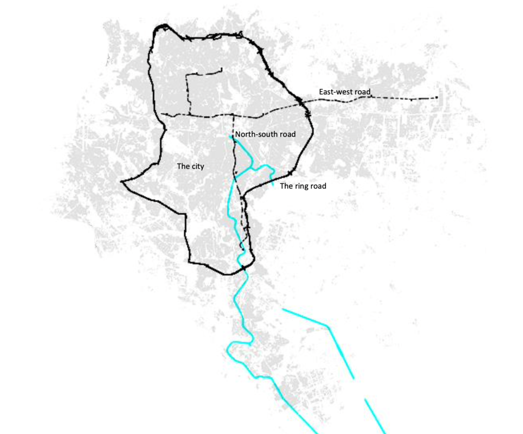
- The ring road is a complete elliptical edge in the city, where it circles and meets major roads in the city centers. The Addis Ababa Ring Road project was initiated within this context, and a contract with a Chinese company (China Road and Bridge Corporation (CRBC)) was signed for 86.2 million us dollars. The contract included the construction of highways, surfacing, and vehicular and pedestrian bridges.
- The plan was to minimize the traffic accidents inside city centers by connecting centers and encouraging pedestrian movements. The system diverted traffic out of the city center and circulates it around the city within its enclosed system that only opens at a few points. The Addis Ababa Ring Road stretches on the east-west line and northeast, covering Tor Hailoch in the west to Ayat Village, the new suburb, and from Menelik Square, the origin of Addis Ababa, to Kality, the industrial part of the city. The east-west line extends 17.35 km, and the north-east extends 16.9 km, with its giant stone and concrete bridges and roads, and walls.
- Seven years after the completion of the ring road, a light rail project was conceived. The Chinese company, Chia Railway Group Limited, got a contract in December 2011, securing funds from the export- Export-Import Bank of China.
- The Addis Ababa Light Rail was originally to have a total of 41 stations on its two lines, and each train was planned can carry 286 passengers. This will enable the light rail transit to provide a transportation service to 15,000 passengers per hour per direction and 60,000 in all four directions. The idea could have been an equivalent of the modern project of Radburn. The challenge of the traffic accident in US cities inspired Henry Wright and Clarence Stein to come up with a different context of roads that could fulfill the mentioned challenges.
- In Radburn, the increase of automobiles, which grew to 21 million within only 30 years, became a challenge for safety and use. The already made grid pattern would not support the massive traffic since it creates an equal distribution of traffic, which makes all streets vehicular-oriented. The roads were also too big to cross on foot, noisy, and polluted. ‘The idea was how to live with Auto’ or ‘how to live despite it’. Out of the challenge, the notion of superblocks was created.
- Superblocks as a simple composition of Superblocks that minimizes the number of vehicles by increasing the block size. The vehicle and the car are separated by space and contact. The playfields that used to be on the street were changed to the midst of the houses on the block, and the carway is away among the superblocks.
The ring road and the light rail re-lived this history.
References
- Fuller M., “City of Addis Ababa and the Colonizing Suburb of EUR ’42: Wherever You Go, There You Are: Fascist Plans for the Colonial”, in: Journal of Contemporary History, Vol. 31 (1996), 397-418.
- INTERNATIONAL CONFERENCE ON MULTI-NATIONAL CONSTRUCTION PROJECTS, “Securing high Performance through Cultural awareness and Dispute Avoidance” SHANGHAI, CHINA, November 21-23, 2008(https://gpc.stanford.edu/sites/default/files/cp028_0.pdf)
- Mikyas Tesfaye Aragaw., ‘’URBAN OPEN SPACE USE IN ADDIS ABABA: THE CASE OF MESKEL SQUARE’’, 2011 Marcus, Harold G. A History of Ethiopia. Berkeley: University of California Press, 1994.
- Richard Pankhurst, ‘’ Menelik and the Foundation of Addis Ababa, in: The Journal of African History, Vol. 2, No. 1 (1961), pp. 103- 117
- Kevin Lynch, ‘’The Image of the City ‘’, 1962
- Alemayehu, Elias Yitbarek, “Revisiting Slums”, Revealing Responses: Urban upgrading in tenant-dominated inner-city settlements, in Addis Ababa, Ethiopia”,2008
- Image sources: https://www.failedarchitecture.com/le-corbusiers-visions-for-fascist-addis-ababa/
- Kebele: smallest administrative unit, equivalent to neighbourhood
Woreda: is a group of kebeles, equivalent to a district - Sub city: recent categorization of districts in Addis Ababa. Today, there are 11 sub-cities in the city, categorized based on their location.

